
Page 66 - Phonebox Magazine April 2010
P. 66
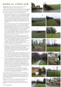
Ramble on; a further walk
ANOTHER EASY WALK, anticlockwise this time from Sherington to Tyringham Bridge and back to Sherington via Water Lane.
Duration: circa 4.75 miles about 2 hours, mostly flat, occasionally undulating with 1 stile. There are no refreshments en-route but 2 public houses in Sherington.
Park carefully in the village possibly in the village hall car park in Church Road (if it’s not being used), or in Gun Lane near the White Hart.
1. Walk up Church Road past the church on your left and turn left into Gun Lane, walk to the far end and cross over the main road bearing slightly right to a stile into a field. Keep to the left in the field beside the hedge, the path has a slow climb up through the field, once at the top of the rise in the middle of the field you may be able to see a small concrete object to your right this is an Ordnance Survey triangulation point. Still following the path by the hedge this now bears right at the bottom of the field (do not go through the gap in the hedge) keep on up to a cross way of paths.
2. At this cross way turn left on to the Three Shires Way keeping the hedge on your right for about 100 yards or so now pass through a gap in the hedge on your right and then keep left. You will now see a specially prepared galloping track for training horses in front of you, (if you have a dog with you please keep them on a lead in case of horses here). Keep to the left of the gallop by the hedge, on this part of the walk there are fine views across farmland to Sherington on your left. The path continues down hill past Bakers Spinney on your left, this used to be the site of cottages that were part of Sherington village, (it must have been a hard life living up here with no services and bringing all of your coal and food across the fields to your home).
3. Where the gallop passes through a gap in the hedge your path turns right, with this low hedge now on your left there are fine views across the Great Ouse valley towards Milton Keynes, follow the path to a small wood, a look through the gate in front will give views across Filgrave to Weston Underwood, Emberton and Olney but turn left into the woodlands called Hill Plantation and follow through the woods where you will now have views over the gate on your right to Stoke Goldington, keep the hedge on your right and pass through 2 gates on to the road leading in to Fences Farm on the left.
4. Turn right on to this road and head towards the main road through from Filgrave and then turn left, you will shortly see the path that goes back to Sherington on your left but carry on past this to the Church, Tyringham Bridge and the interesting arched gatehouse built by Sir John Soanes in the 1790’s (this gate house is still occupied today with the living quarters on either side of the road) this point is the end of the Three Shires Way for today.
5. From the bridge there are fine views back to Tyringham Hall on your left also now in private hands after many years as a health clinic. There is a seat in a small enclosed garden by the ornamental gates where you can sit and catch your breath and admire the views or have refreshments if you have brought any with you. Walk back up the road past the Church.
6. The path goes through a gate on your right into a field, keep on through 2 gates into a large field and then bear right down towards the river and at the trees keep left (there is no river path) although it can be seen through the trees with occasional sightings of Herons and Swans etc. The path now leads though more gates and fields passing a metal windmill, this was used to pump water from the Great Ouse up to the farm house at Fences Farm. The path then leads through more fields to the outskirts of Sherington at End Farm with its new cottages being a recent development and addition to the village.
7. This is now the start of Water Lane, with fields to either side and eventually a small factory yard on the right and then cottages and houses leading up past the Shooting Grounds to the High Street and the Knoll, site of the village May Day celebrations.
Cross the High Street and walk up Church Road to your parking place.
We hope that this walk has been of interest to you, it has some fine views particularly on a clear day and historic buildings which would be worth looking up for more detail. Additionally the village of Gayhurst has links to the gunpowder plot and there are good views form Sherington Church across to Hanslope spire.
Perhaps now is the time to try some refreshments in the village, please remember to close all gates after you and take any litter home.
It should be noted that between points 2-4 and 6-7 that there is the possibility of horses and cattle so dogs should be kept on a lead at this time.
1
2
3
5
4
1
5
66 Phonebox Magazine
6
