
Page 73 - Phonebox Magazine November 2012
P. 73
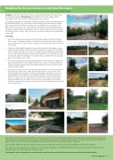
Rambling On: An anti-clockwise walk from Sherington
A local walk with great views of Chicheley, North Crawley, Olney and across to Milton Keynes.
Duration: circa 4.5 miles about 2 hours, an easy walk through the fields around the village (no stiles). Refreshments: at the White Hart or the village shop in Sherington and in the tea room at Alban Hill Nursery if open.
Sherington is two miles from Newport Pagnell and three miles from Olney just off the A422 and A509. For convenience we are starting the walk from the village hall car park in Church Road, however, there is parking in the car park of the White Hart in Gun Lane if you were going to use this for your refreshments and cleared the parking with the landlord or there is further parking in the car park of the sports ground in Perry Lane. If there are events on please park considerately in the road.
The Route:
1. From the village hall turn right up Church Road and then right in to School Lane, at the T junction turn left in to Croft End and soon bear left in to Perry Lane, continue on up the road as it crosses the by-pass and then on to a fork in the track.
2. Take the left hand path around the edge of the field with the hedge on your right, the path will take a right hand turn through the hedge and in to another field. In about 20 yards or so turn left through a gate and keeping the hedge on your right follow this path through two fields until it turns left at the far end of the fields and then through in to a further field eventually there is a largish gap in the hedge on your right.
3. Turn right through here and then immediately turn left for about 15 yards to a gate, this leads down to the A509, caution here, cross the road towards the nursery and then again across Sherington High Street to enter a field with a wide iron barred gate.
4. Keeping the hedge on your right for just under a mile or so to a cross way of paths at a spinney (to the right leads towards Filgrave and over the road towards Emberton, straight on will lead eventually to Tyringham- one of our earlier walks in this series). Turn left with the hedge on your left follow the track for 1.5 miles, at the T junction turn left and then follow this track as it becomes Water Lane for about one mile to the cross roads in Sherington. Cross the road with the Knoll on your left in to Church Road and then back up to the village hall.
4
4 4
1 1 1
2 2
2
33 4433
The idea behind these occasional walks is to encourage us to visit our neighbouring villages and to enjoy their surrounding countryside, the different season can greatly effect the scenery, with delightful flowers in the meadows and woodlands in spring time, and crisp clear frosty days in winter can often increase the distance you can see as well as blow away those winter cobwebs.
Reversing the walks can also give different views that you might miss in one direction and add another walk to your repertoire.
The walks can be traced using the Ordnance Survey Explorer Maps No.s: 192/207/208/223/224 which contain a wealth of information for planning walks within the Phonebox catchment area.
There may well be cattle, sheep and horses in some of the pastures, so please keep dogs on a short lead at these points, please close all the gates and take litter home.
Phonebox Magazine 73
