
Page 26 - January Phonebox Magazine 2012
P. 26
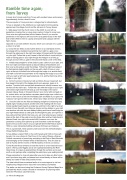
Ramble time again; from Turvey
A lovely short circular walk from Turvey with excellent views and scenery. Approximately 4 miles, about 2 hours.
There are pubs in Turvey and also a village shop for refreshments.
Turvey is situated on the A428 and our walk starts from the parking spaces near the village church and the entrance to Turvey House.
1. Walk away from the church down to the A428, to your left is a pedestrian crossing; this is a busy main road so it’s best to cross here. Once over turn right and then left into Newton Road, if you use the pavement on the right you will soon arrive at a gated recess in the wall that is Nell’s Well in here is a pump and bucket and a plaque with the Nell’s rhyme.
Opposite is our track between houses, which soon narrows in to a path to a stile in to a field.
2. Cross the two fields via two further stiles in to a small band of trees, here keep left to a metalled road and then turn right to a gate, once through the gate keep to the right hand edge of the park with the hedge on your right. Follow this up as it bears to the left follow it round until you reach a kissing gate on your right through the hedge in to a field, go through and turn left to a gate in the bottom left hand corner of the field.
3. Initiallykeepstraightforafewyardstopassaditchonyourright,and then turn right and head towards a disused railway embankment and then over a stile and go under the bridge. Follow the right hand edge of the field gaining height slightly on the way with a belt of trees on your right, at the top of the field turn left through the hedge in to another field, and walk round left hand perimeter of this keeping the hedge on your left until you reach a left hand waymarked sign in to another field now with a hedge on your right.
4. AttheTjunctionoftracksturnleftandfollowthisasitbearsleft,but then keep to the right of the hedge which soon appears, keep on to another T junction (with a small path ahead across a field) however turn left here on the main track. Follow this track with the hedge on your right until it bears right and then left and go over the bridge of the same disused railway. Keep on this path where it soon turns right and walk on for a short while, and just before a wooden plank bridge over a ditch turn left in to the trees to a stile into the Abbey park and fields (if you get to the road you have gone a little too far, retrace your steps and now turn right).
5. Crossthestileintothefieldandkeepingstraightonbutbearingvery slightly right, heading towards another stile, then walking with the road mostly parallel head towards a single tree and then to the right of a small clump of trees the path now follows a stream and low bridge on your right over another stile with the main Abbey building and then a small lodge on your right head towards a cattle grid and through the gate, turn right for a few yards and then left into the trees, you are now retracing your original steps at the start of the walk across the three stiles and two fields back to Newton Road, turn right to the main A428, however once over the pedestrian crossing turn right and go anti-clockwise round the triangle back to the car at the church on your right will be the Old Rectory built in 1839 is a very interesting building with great chimneys and features.
This is a great walk, which passes under and over the old Northampton, Olney, Bedford Railway line.
Turvey Abbey is dated 1605 on the north facade and 1608 on the south facade. It is now is home to The Priory of Our Lady of Peace a Roman CatholiccommunityofnunslivingaccordingtotheRuleofS
 aintBenedict and belonging to the Olivetan family of Benedictines. They live side by side at Turvey with the monks of the Monastery of Christ our Saviour.
Turvey House whose entrance is near the church is a neo-classical house built in 1792 by John Higgins and is set in parkland bordering the River Great Ouse. It is open at selected times through the summer and is well worth a visit, perhaps after completing the walk (minus your walking boots)!
Please remember to close all gates after you and to take any litter home, and if you have dogs with you please have a lead handy, as there will be sheep and cattle in fields and possibly horses.
The idea behind these occasional walks is to encourage us to visit our neighbouring villages and to enjoy their surrounding countryside.
The walks can be traced using the Ordnance Survey Explorer Maps No.s 207/208/192 which contain a wealth of information for planning walks within the Phonebox catchment area.
2
3
3
3
26 Phonebox Magazine
2
2
4
4
4
4
5
5
1
1
